A new Chinese heliport, which is being constructed 20 kilometres east of the Line of Actual Control in the sensitive ‘Fishtails’ region of Arunachal Pradesh, may enable the Chinese armed forces to rapidly deploy military resources into a remote, underdeveloped area along the Indo-Chinese frontier.
The heliport, which is depicted in this report, is situated in the Nyingchi Prefecture of the Tibet Autonomous Region, along the banks of the Gongrigabu Qu river. India does not dispute the fact that this is located within Chinese territory.
The site where the heliport is being constructed was not under construction as of December 1, 2023, as evidenced by open-source satellite imagery available on EOS Data Analytics. Land is being cleared for construction in a subsequent satellite image, which was taken on December 31. The facility is in an advanced state of construction, as indicated by the most recent high-resolution images from Maxar, which were captured on September 16.
Damien Symon, a geospatial intelligence expert who was the first to identify the heliport, has noted that “this new heliport will enable the People’s Liberation Army (PLA) to enhance intelligence-gathering, surveillance, and reconnaissance activities.” This resolves logistical obstacles in the densely forested region, which is characterised by rugged mountains that complicate military operations. The heliport’s development “enables rapid troop deployment to distant areas, strengthening patrol efficiency and augmenting China’s overall military footprint in these strategically important, remote locations.”
China is constructing a new heliport near Arunachal Pradesh’s ‘Fishtails’ sector, merely 20 kilometers from the Indian border, this facility will likely enhance China’s ability to swiftly mobilize troops to forward positions & would improve its border patrols pic.twitter.com/xpSSQGLkS4
— Damien Symon (@detresfa_) September 16, 2024
Military sources who are overseeing the construction of the heliport assert that, although “this is definitely military infrastructure being constructed,” the new facility may also serve a dual purpose by facilitating the movement of civilians into the remote area. They also note that the heliport improves Chinese “defensive and offensive operations” and their “reaction capabilities.” This facilitates the rapid mobilisation of troops during a contingency.
The Fishtails area of Arunachal Pradesh is divided into two sections: Fishtail 1 and Fishtail 2. The name “Fishtails” is derived from the unique shape of the boundary line in the region. Fishtail 1 is situated in the Dibang Valley, whereas Fishtail 2 is partially located in the Anjaw district of the state. In other words, both regions are classified as “sensitive,” meaning that China and India hold varying perspectives on the Line of Actual Control.
“This heliport will pose a threat to critical areas that are deemed “sensitive” in this region,” asserts Lieutenant General Pravin Bakshi (retired), who served as the Eastern Command commander of the Indian Army. “I will take serious note and look to orchestrate a suitable response, if ever required, in concern with the Indian Air Force so as to prevent any ‘grey-zone’ warfare being efficiently prosecuted by the Chinese here.” Grey-zone warfare is a type of conflict that is not classified as conventional war, but still poses a threat to boundary lines by employing coercive measures that undermine stability.
Breaking: Chinese foreign ministry says Front-line armies of India, China have “realized disengagement in four areas” in the Western sector of the China-India border, including the Galwan Valley.
Transcript from Chinese foreign ministry press conference https://t.co/lRoYlC9Z7c pic.twitter.com/wCl8cEsuox
— Sidhant Sibal (@sidhant) September 13, 2024
The heliport that is currently being constructed has a 600-meter runway that is capable of accommodating rolling take-offs for helicopters. This technique is employed in high-altitude regions where helicopters have limited power. The new heliport is located in an area where the altitude is significantly lower than that of large portions of the Tibetan plateau, despite the presence of a runway. This is advantageous for helicopter operations. “While the rest of the plateau has a disadvantage because of altitude, the general altitude in this area is in the 1500 metre (approximately 5000 feet) range which allows greater payload to be carried by choppers and aircraft.”
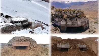
Additionally, the heliport includes an air traffic control facility, a substantial apron area for helicopters to be positioned, and associated buildings and structures.
At the same time that Beijing is in the process of constructing hundreds of ‘Xiaokang’ or dual-use villages along the frontier with India, China is constructing a new heliport. These villages are a means for China to substantiate its claims in disputed regions along the Line of Actual Control. China has engaged in the “salami slicing” of territory, a term coined by the late Chief of Defence Staff General Bipin Rawat, by constructing these villages and altering the facts of the ground. This has been particularly apparent in the Kingdom of Bhutan, where the Chinese have physically occupied undefended areas of its border regions, including the ancestral lands of its royal family. The Chinese have constructed townships that are connected by a vast road network.
Brahma Chellaney, a prominent strategic affairs expert who concentrates on China, explains, “This demonstrates how China is quietly establishing new facts on the ground.” “The current efforts to defuse the military standoff raise the question as to what a possible deal can accomplish, given the new military realities China has created along the Line of Actual Control (LAC) since 2020.”
India, which has been in protracted negotiations with China since the violent skirmishes of 2020 in Ladakh, has initiated the ‘Vibrant Villages’ development project to counteract China’s border strategy. This project encompasses 3,000 villages in four Northeastern border states, including Arunachal Pradesh. The initial phase of the project has been allocated ₹ 4,800 crore. Additionally, a 2,400-kilometer trans-Arunachal highway is currently under construction, which will significantly reduce travel time, particularly in Eastern Arunachal Pradesh. The highway, in conjunction with other road projects in the state, also facilitates access to frontline Army posts.
However, the construction of the new heliport, which shifts pressure to the east of Arunachal Pradesh, “opens up a new vista,” according to Lt General Bakshi. Despite the rapid development of infrastructure along the frontier, “This area remains the least developed in our area of responsibility.”
-
-

-

-